Seismic Surveys

WHAT ARE SEISMIC SURVEYS?
Seismic surveys are undertaken during marine oil and gas exploration to investigate the geological formations beneath the seabed.
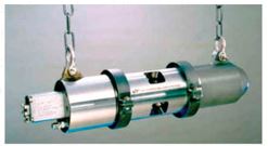
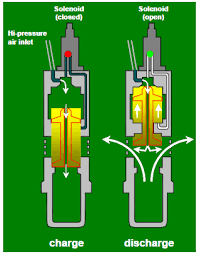
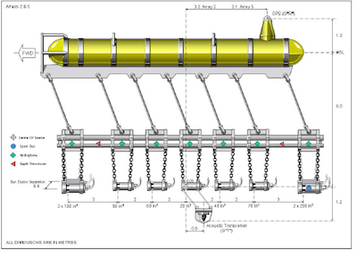
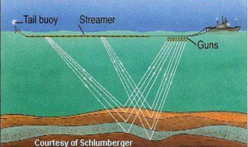
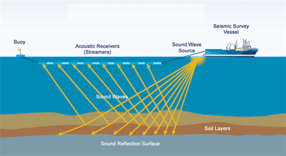
In modern seismic surveys, airguns (FIGURE 1) are used as the sound source, which are underwater pneumatic devices from which high-pressure air is rapidly released into the water column (FIGURE 2). Upon release of the air, the bubbles pulsate rapidly producing acoustic signals which are proportional to the rate of change of the volume of the bubble. The frequency of the signal is dependent on the energy of the compressed air prior to discharge. Airguns can be used concurrently with a variable number of guns in what is called an array (FIGURE 3), a typical array is comprised of between 12 and 70 airguns. The airguns would be fired within milliseconds of each other at intervals of between 10 to 20 seconds. These air guns are towed at approximately 80-150m behind the vessel at a depth of between 5-25m.
Towed behind the airguns is a configuration of cables with mounted hydrophones and geophones, called steamers. The streamers are towed at a depth of between 6-30m and not visible on the surface, with the exception of the tail-buoys on the far-end of the streamers which can be seen on the surface. A configuration of steamers can be up to 12 km in length behind a vessel.
The number of and layout of these streamers are dependent on whether the surveys are 2D or 3D. 2D surveys have a single streamer (FIGURE 5), while 3D surveys have multiple streamers (FIGURE 6), which can be up to 12 streamers spaced 100m apart. 2D surveys are typically used to obtain data from survey grids, from 1km to tens of kilometres. Effectively, a 2D survey provides a vertical slice, illustrating depth of different sediment densities through the earth’s crust along a survey line. These 2D surveys are undertaken when the potential of oil & gas deposits are unknown, while 3D surveys are undertaken areas when it is likely that there are the presence of oil & gas deposits. 3D surveys are undertaken to determine, faults, distribution of sediments, estimates of oil and gas in situ and to provide potential locations for exploration wells. 3D surveys requires multiple traverses over the area of interest.
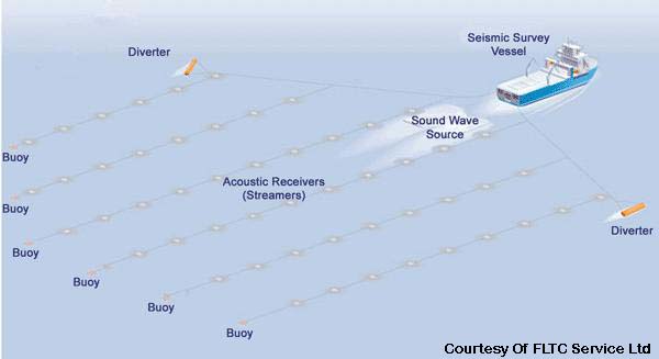
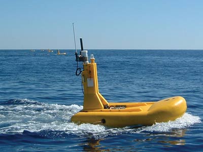
The tail buoy at the end of the streamers (FIGURE 7) is a floating device used to identify the end of the streamer, monitor their location and the direction of the streamers.
When the seismic surveys are taking place, i.e. the airguns are in operation and firing, the vessel is typically traveling at between 4-6 knots (2-3 meters per second). The airguns fire high intensity, low frequency sound waves directed towards the sea bed which are reflected from geological formations which are received and recorded by the many hydrophones and geophones mounted within the streamers (FIGURE 8). The data received are interpreted and the specifics of the geological formations below the sea bed are interpreted and analysed (FIGURE 9).

References:
Cameselle, A.L. 2010. Mapping of sedimentary bodies by 3D seismic reflection data: an application to the pre-Mesinian Ebro Margin. Universitat de Barcelona & Universitat Ramón Llull Barcelona, Spain, Department of Geophysics. MSc Thesis. 93pp.
